Fenner Seminar: Digital Earth Africa Flash Talks
This session will comprise a series of flash talks delivered by visiting members of the Digital Earth Africa community. Digital Earth Africa exists to improve the lives of people across the African continent by translating Earth observations (EO) into insights that will support sustainable development.
Speakers
Content navigation
Description

Digital Earth Africa Flash Talks
This session will comprise a series of flash talks delivered by visiting members of the Digital Earth Africa community. Digital Earth Africa exists to improve the lives of people across the African continent by translating Earth observations (EO) into insights that will support sustainable development. The program makes EO data free and accessible, delivering decision-ready products to the African continent.
The session will be chaired by Dr Michael Wellington, who completed his PhD on remote sensing for water productivity at African irrigation schemes at the Fenner School in 2022. He is currently the manager – EO product development for Digital Earth Africa at Geoscience Australia.

Speakers
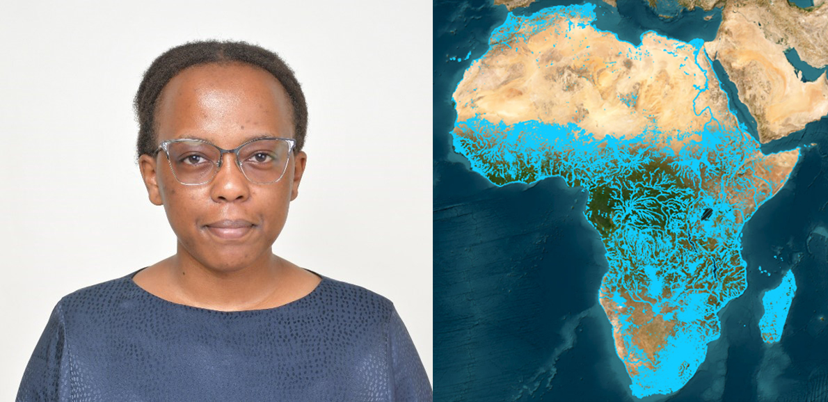
Mpho Sadiki - Leveraging the Digital Earth Africa platform to map and monitor African wetlands.

Abstract: Presenting a wetland mapping and monitoring initiative within the Digital Earth Africa platform, aimed at developing end-to-end workflows primarily focused on mapping and monitoring wetlands using a set of complementary Jupyter notebooks.
Bio: Mpho Sadiki is an Earth Observation (EO) Data Scientist for Digital Earth Africa, working to develop EO-based sustainable solutions for the continent. Alongside her role, she passionately explores wetland ecosystems, currently pursuing a PhD in geoinformatics at the University of Pretoria, South Africa, with a focus on mapping their biodiversity across Africa.
Edward Boamah - Digital Earth Africa: Unlocking Access to Analysis-Ready Satellite Data for Africa

Abstract: Africa now has ready and reliable access to over 3PB of analysis-ready satellite data from Landsat, Sentinel-2, and Sentinel-1, as well as a range of other key datasets, stored in Cape Town by AWS in a cloud-optimized format suitable for rapid analysis and machine learning (ML). Data stores are continuously updated, and new decision-ready information is generated for the entire continent at full resolution (usually 10 or 30 meters). Services include dynamic water extent (Water Observations from Space), coastline, cropland extent, fractional cover, and monthly NDVI analysis. A Geo-Median (GeoMAD) service provides annual and semiannual cloud-free surface reflectance and variability measures that can be used for visualization, land cover mapping, and change detection.
Bio: Edward Boamah works as the Technical Manager for Digital Earth Africa, where I support institutions and countries within Africa to make use of the Analysis Ready Earth Observation (EO) data for impact and decision making. My vision is that all Africans, from highly technical professionals to government, policymakers, and civil society, will embrace DE Africa. I am most passionate about sharing how EO can be used for managing water, understanding deforestation impacts, and informing city planning and urbanization, but sees EO being used by everyone and anyone because of how easily accessible it will be.
Abstract: The DE Africa Waterbodies Service is a preliminary continental service that maps over 700,000 waterbodies across Africa and the change in their water surface area for over 3 decades. This service helps improve our understanding of water availability across Africa which is very important because of the increased frequency of natural disasters caused by climate change that have and continue to affect access and availability of water.
Bio: Victoria Neema is an Earth Observation Scientist for Digital Earth Africa where she supports the design and development of new DE Africa earth observation continental services and products. She is based in Nairobi, Kenya.
Dr. Jokotola Omidiji - Improving flood risk mapping and building a case for more floodable landscapes in Lagos Megacity, Nigeria
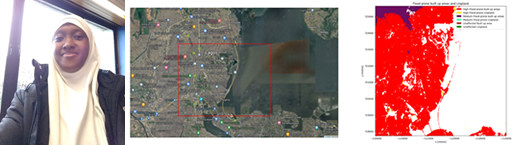
Abstract: Flooding poses a significant challenge worldwide, especially in densely populated urban areas like Lagos, Nigeria, where climate change, rapid urbanization, and inadequate planning increase vulnerabilities. This presentation introduces "floodable spaces" as a novel approach to mitigate flooding in Lagos by designing specific areas to absorb floodwaters, thereby reducing risks while enhancing ecological health and urban resilience. Dr. Omidiji will discuss potential locations for these spaces and the challenges of implementing them in highly urbanized settings, highlighting the importance of integrating flood risk mitigation into urban planning.
Bio: Dr. Jokotola Omidiji holds a Bachelor and Master of Science degree in Geography and Planning from the University of Lagos, Nigeria, as well as a doctorate degree in Physical Geography from the University of Otago, New Zealand, specializing in coastal geomorphology. As a geomorphologist and heritage and social scientist, I am interested in understanding the relationships between coastal morphodynamics, heritage conservation, and environmental management. My research aims to contribute to achieving SDGs 6.6, 11, 13, 14, and 15. With over a decade of experience, my evidence-based research incorporating field observations, aerial surveys, satellite data and geospatial analysis has contributed to the development of resilience strategies for vulnerable shorelines and coastal communities. I enjoy working with local communities and mentoring the next generation of scientists to foster innovative approaches to solving complex environmental problems.
Location
Fenner Seminar Room and via Zoom