Reading desert sands – Indigenous wildlife tracking skills underpin vast monitoring project
By Sarah Legge, Australian National University; Braedan Taylor, Indigenous Knowledge; Jaana Dielenberg, Charles Darwin University; Pius Gregory, Indigenous Knowledge, and Rachel Paltridge, The University of Western Australia
As animals move across the desert, they leave tracks, diggings and droppings. For skilled trackers, reading these signs is like watching a movie. A story of who was there and what they were doing unfolds in front of them.
In this way, many Indigenous Australians know where the goannas (jalangardi in Yawuru) are fat and abundant, when bilby (jitartu in Karajarri) burrows are occupied, and whether the bush turkeys (parrkara in Karajarri) have arrived to take advantage of a freshly burnt patch.
For many years, scientists have been working with Indigenous people in the desert to record these observations in a systematic way. Taking a standard approach enables comparisons between data from different people, times and places, so trends can be detected.
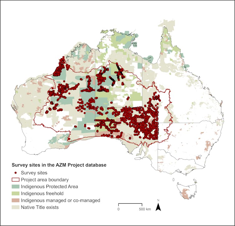
Our new research collates almost 49,000 animal detections during 15,000 surveys at more than 5,300 sites, since 1982. This unique data set reveals new information about desert species. Monitoring animal numbers, locations and responses to environmental change is vital for guiding efforts to support their survival.
This video features reflections from people involved in the Arid Zone Monitoring project, including authors Sarah Legge and Braedan Taylor. (Threatened Species Recovery Hub).
Monitoring desert wildlife is a skill
It’s not always easy to see animals in the desert. Most are nocturnal, secretive, and spend much of their time underground. Numbers can fluctuate widely, dwindling during droughts and booming after rain.
This means we need to collect a lot of data — over a long time and over a vast area — to tell what is going on.
Fortunately, Indigenous Australians continue to inhabit and look after desert landscapes using deep knowledge of their Country and exceptional observational skills. Our deserts contain one of the largest networks of Indigenous-managed land in the world.
The Arid Zone Monitoring Project combines Traditional ecological knowledge and tracking skills with scientific analysis. Indigenous rangers and Traditional Owners from 33 different Indigenous desert groups are involved, along with government agencies, non-government organisations and independent scientists. It’s one of Australia’s largest wildlife monitoring endeavours, spanning nearly half of the country.
 More than 5,300 unique sites More than 5,300 unique sites are spread across deserts with various types of Indigenous land tenure and management. The project area boundary follows regional boundaries based on geology and ecology. Sarah Legge.
Fresh insights
The standard approach is to search a 2-hectare area for signs of animals with at least two people for 20 minutes.
One of us, Braedan Taylor, has performed many dozens of these sign-based surveys. He says: “Within these areas we look for scats (poo), burrows, tracks and record everything that we find.”
The observations are recorded on various apps or paper record sheets.
The method has been widely embraced by Indigenous ranger teams. But, until now, the data has generally stayed within those teams.
By bringing all of the data together for analysis, our research has revealed fresh insights into desert wildlife. We now know more about where species occur and their preferred habitats. We found some species in places where they were not thought to exist before.
For example, it turns out the range of the great desert skink (tjakura in Wiluna Martu Wangka) extends further southwest in Martu Country than previously thought. This chunky, group-living reptile is culturally important to Indigenous people. While local people knew of its presence, sharing that knowledge helps conserve this threatened species.
Learn how to track Tjakura (great desert skink) and see how rangers and custodians are monitoring and caring for this threatened, culturally significant species. (Indigenous Desert Alliance)
In the northwestern deserts, Yawuru Country managers and Karajarri rangers recorded many observations of spectacled-hare wallabies (manggaban in Yawuru). This species had not been detected in the region for more than a decade. One of us, Pius Gregory, worked with his countrymen, using careful observation of scats (poo) to distinguish this species from two other wallaby species of similar size (northern nailtail wallabies, agile wallabies; garrabulu, barrjaniny).
Analysing the data has also improved our knowledge of where pest species occur and how they may be affecting native wildlife. For example, we found bilbies have been lost from 70% of their former range, contracting to the northwest deserts where fox density is lowest. Feral cat numbers are also higher here, perhaps also due to fewer foxes.
Some species leave more tell-tale signs
Better monitoring can help ranger teams evaluate their programs to control fires and feral animals.
The data can also help determine the conservation status of threatened species, and whether it’s improving or declining.
Species detection rates, locations and habitat preferences can also inform future monitoring programs. This includes guiding where and how often to survey, to detect population changes for various species.
Overall, we found sign-based surveys are great for monitoring 28 species of mammals, reptiles and birds – including threatened, invasive and culturally significant species. This includes game species that are important to desert people such as kangaroo (mirtimarlu in Karajarri), emu (bijarda in Yawuru) and bush turkey (bustard, barrgara in Yawuru).
We found a national monitoring program for these 28 species would only require visiting 600 strategically located sites twice every five years. Each team involved in the monitoring would need to survey only 10–20 sites a year.
We identified a further 48 species in the records, but found sign-based surveys may not be the best way to monitor them. This is either because detections are too few, or their sign is hard to identify.
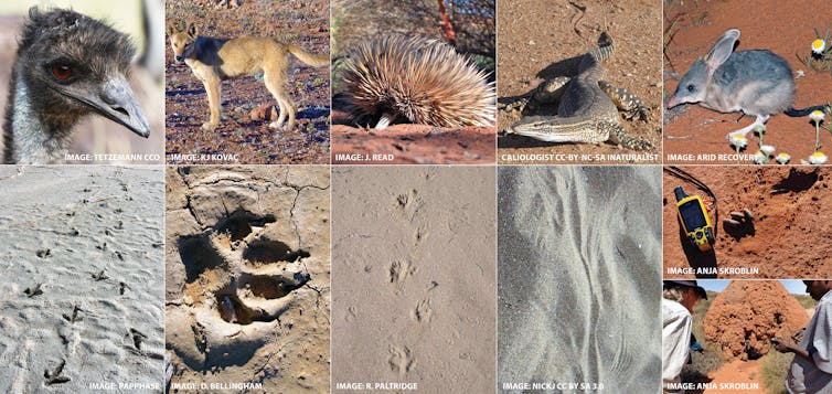
For some of those species, extra training by expert trackers may make a difference. For example, the tracks of red kangaroo, euro and grey kangaroo are hard to distinguish for inexperienced trackers, as are perentie, yellow-spotted and sand goanna tracks.
Emu, dingo, echidna, and sand goanna tracks – and bilby scats.Arid Zone Monitoring project. See images for individual attributions.
Potential for the future
The Arid Zone Monitoring Project was a proof of concept that showed how much monitoring is already being done by rangers. It also shows the potential for a desert-wide monitoring program, in which Indigenous-led data collection is paired with logistic, analytical and funding support.
Such a program could provide information on biodiversity trends over 40% of the country. This would help inform invasive animal control programs, as well as Indigenous-led recovery strategies for threatened species and culturally significant species.
Sign-based monitoring gives elders and senior rangers an opportunity to share information and skills. This extends beyond tracking, to language, stories, and all aspects of cultural and ecological knowledge. Pius and Braedan can’t overstate how important this is – sign-based surveys are a great way to get out on Country and learn.
The wellbeing of Indigenous Australians is inseparable from the wellbeing of Country: (“healthy Country, healthy people”). Effective monitoring, with strong Indigenous engagement, is a essential for looking after the plants, animals and people of Australia’s desert Country.
We sincerely acknowledge the many people who contributed to this research.
Bustard tracks across a dune on Anangu Country. Jaana Dielenberg / Biodiversity Council
This article is republished from The Conversation under a Creative Commons license. Read the original article.


